
The Met Office provides free, real-time rainfall radar data across the United Kingdom, enabling people to track precipitation patterns for their local area and plan accordingly. Accessing this information is straightforward through the official website or mobile application, with additional options available from independent weather services.
Whether you need to monitor rain approaching London, track showers moving through Manchester, or view broader UK conditions, the available tools offer comprehensive coverage with updates every few minutes. Understanding how to navigate these resources effectively helps ensure you stay informed about weather conditions that could affect daily activities or travel plans.
This guide covers the primary methods for accessing Met Office rainfall radar data, including location-specific options, supplementary satellite imagery, and European coverage details.
Accessing Met Office Rainfall Radar Near London and Manchester
The Met Office offers direct access to rainfall radar imagery through its official website, providing real-time precipitation data for cities across the United Kingdom. Both London and Manchester residents can view local conditions by selecting their specific location within the service.
Enter your city name directly in the search function on the Met Office maps page to automatically load local radar data and forecasts.
Key Features Overview
UK-wide precipitation with 48-hour history and 5-day forecasts
Real-time data refreshed at regular intervals
Available via web browser and mobile application
Essential Insights
- The radar displays live precipitation rates across the United Kingdom, distinguishing between rain, sleet, and snow
- Resolution updates occur at intervals between 5 and 15 minutes depending on location
- The system draws data from the NIMROD weather radar network
- Mobile app users receive automatic location-based alerts for approaching weather systems
- Historical data extends back 48 hours, allowing comparison with current conditions
- London forecasts recently showed sunny intervals at 17°C with less than 5% rain probability in the immediate hour
- Manchester conditions typically reflect cooler temperatures with varying precipitation levels
Quick Reference Data
| Feature | Details |
|---|---|
| Update Interval | 5–15 minutes |
| Primary Coverage | United Kingdom |
| Extended Coverage | Partial Europe visibility |
| Access Cost | Free for web and mobile app |
| Data Source | NIMROD radar system |
| Historical Range | 48 hours |
| Forecast Horizon | 5 days |
| Mobile Platform | Android (Google Play) |
Live Weather Radar Maps for the UK
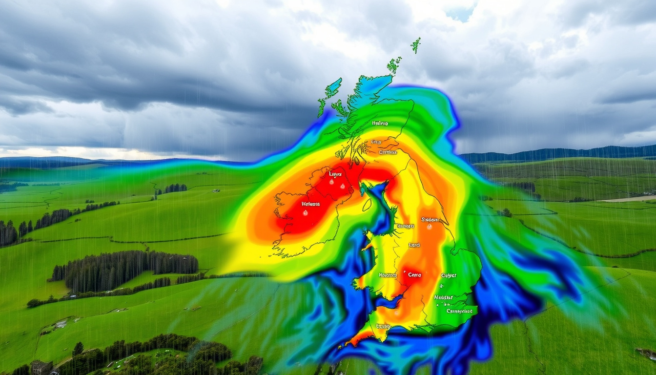
The primary tool for viewing live precipitation across the United Kingdom is the Rainfall Radar Map available on the Met Office website. This interactive display shows current rainfall intensity across the entire country, with the ability to animate the past several hours of data.
Users can zoom into specific regions, including metropolitan areas like London and Manchester, to see granular precipitation patterns. The map overlays forecast data extending five days ahead, helping plan for upcoming weather changes rather than just monitoring current conditions.
Using the UK Weather Map
The UK Weather Map complements the rainfall radar by displaying comprehensive weather data alongside precipitation information. This tool combines current observations with forecast projections, including temperature, wind speed, and precipitation probability.
Both the rainfall radar and weather map update throughout the day, reflecting the latest data from weather stations and radar installations across the country. The Met Office recommends refreshing pages periodically when monitoring developing weather situations.
Independent platforms like Netweather and Meteoradar offer additional radar views with different visualization approaches and update frequencies.
Independent Radar Providers
Netweather provides free live UK radar imagery refreshed every 5 minutes, tracking rain, sleet, and snow across the country. The service is accessible at www.netweather.tv/live-weather/radar, with premium subscribers gaining access to faster updates, lightning detection, and an ad-free experience.
Meteoradar offers similar functionality with worldwide coverage focused on the United Kingdom and Europe. Users can access playback features, pause and freeze imagery, and view three-hour precipitation forecasts. The service is operated by Infoplaza and affiliated with Sat24.com satellite products.
Mobile Application Access
The Met Office mobile application, available free on Google Play, provides comprehensive radar access on smartphones and tablets. The app includes interactive rainfall radar showing the last six hours of precipitation history, severe weather warnings, and hourly forecasts for locations including London and Manchester.
Additional features include real-time alerts for rain, snow, and thunderstorms, along with wind speed indicators, UV levels, and pollen forecasts. Location services enable automatic tracking of conditions at your current position without manual searching.
Met Office Weather Satellite UK Tracker Live
While the Met Office does not offer a standalone “satellite tracker” page, the official website and mobile application integrate satellite-derived imagery within their weather mapping tools. This satellite data supplements radar observations by showing cloud cover and movement patterns that precede precipitation.
The Met Office app includes satellite-like map layers that display cloud formations across the United Kingdom and surrounding regions. These visual aids help users identify weather systems approaching from the Atlantic or moving across continental Europe.
Satellite imagery appears within weather map layers rather than as a separate tracker tool. For dedicated European satellite views, Meteoradar links to Sat24.com products.
Satellite View Access Methods
- Met Office mobile app includes satellite map layers alongside radar data
- Meteoradar provides direct access to Sat24.com satellite imagery for Europe-wide views
- The Met Office YouTube channel features regular forecast videos explaining satellite analysis
- Weather & Radar UK app offers TemperatureRadar alongside satellite-derived cloud imagery
Met Office YouTube Channel
The official Met Office YouTube channel (@metoffice) publishes live UK forecasts and severe weather updates that incorporate satellite analysis. These videos explain current conditions and forecast reasoning, providing context that complements the raw data available on the website.
Met Office Rainfall Radar Coverage in Europe
The Met Office radar network primarily focuses on United Kingdom territory, providing comprehensive coverage of England, Scotland, Wales, and Northern Ireland. However, edge coverage extends into some neighboring maritime areas, offering limited visibility into parts of Western Europe.
For users specifically interested in European precipitation patterns, independent services provide broader geographic coverage that complements the UK-focused Met Office data.
Europe-Wide Radar Options
Meteoradar specializes in European precipitation data, offering views that extend well beyond UK boundaries. The service displays rainfall charts for cities across the continent, including London with temperatures ranging from 11°C to 18°C and Manchester conditions showing 8°C to 15°C ranges alongside varying precipitation amounts.
The platform includes playback functionality that allows users to review past precipitation movements, helping identify storm tracks and weather system progression across multiple countries.
For continental European precipitation, consider using Meteoradar or accessing Sat24.com directly for the most comprehensive satellite and radar coverage.
Data Refresh and Update Schedule
Understanding when radar data updates helps users know when they are viewing the most current information available. The Met Office radar system refreshes at intervals between 5 and 15 minutes depending on the specific radar installation and geographic location.
- Live observations: Current radar scans updated every 5–15 minutes depending on location
- 48-hour history: Archival data accessible for recent precipitation pattern analysis
- 3-hour forecasts: Near-term precipitation predictions updated with each radar cycle
- 5-day outlook: Extended forecast integration with radar-tracked weather systems
- Hourly forecasts: Updated multiple times daily based on evolving conditions
- Severe weather alerts: Triggered immediately when radar detects significant precipitation development
Established Facts and Areas of Uncertainty
| Established Information | Remaining Uncertainty |
|---|---|
| UK radar data updates at 5–15 minute intervals | Exact timing of individual radar station refresh cycles |
| Met Office offers free web and mobile access | Future app availability on iOS devices beyond Android |
| Radar uses NIMROD system technology | Specific technical specifications for public users |
| Data covers UK primary with partial Europe edge visibility | Precise geographic limits of Europe coverage extent |
| Mobile app includes location-based alerts | Alert sensitivity thresholds and notification timing |
| Forecast horizon extends 5 days | Accuracy degradation timeline for extended forecasts |
| Netweather updates every 5 minutes | Specific coverage differences between Met Office and alternatives |
How Radar Technology Works
Weather radar installations emit pulses of microwave radiation that bounce off precipitation particles in the atmosphere. By measuring the time delay and intensity of returning signals, the system calculates rainfall location, intensity, and movement direction.
The Met Office operates multiple radar installations across the United Kingdom as part of the NIMROD network, combining data from individual stations into a composite national image. This network approach ensures comprehensive coverage even when individual installations face temporary interference or maintenance.
Satellite observations complement radar data by providing broader atmospheric context. While radar shows precipitation already reaching the surface, satellite imagery reveals developing cloud systems and storm formations that may produce rainfall within the following hours.
Source Verification and Data Reliability
“The Met Office provides official, free real-time rainfall radar, UK weather maps, and forecasts covering London, Manchester, and nationwide areas.”
— Met Office official documentation
All information presented derives from official Met Office sources, independent weather services with established reputations, or documented capabilities from recognized platforms. Where uncertainty exists regarding specific technical details or coverage boundaries, that limitation has been noted explicitly.
Summary and Practical Steps
Accessing Met Office rainfall radar data for London, Manchester, or any UK location involves either visiting the official website maps section or downloading the mobile application. Both options provide free access to real-time precipitation data, 48-hour historical views, and five-day forecasts.
For users requiring broader European coverage or alternative visualization approaches, independent services like Netweather and Meteoradar offer supplementary tools. Satellite imagery remains available through the Met Office app and affiliated platforms, though not as a standalone tracker product.
Enable location services on mobile devices for automatic local tracking, and consider bookmarking the Rainfall Radar Map for quick access when monitoring developing weather situations.
Frequently Asked Questions
How often does the Met Office rainfall radar update?
Radar data refreshes at intervals between 5 and 15 minutes depending on the specific radar installation location. The Met Office website and app display the most recent available data whenever you access the service.
Can I view Met Office radar data on my phone?
Yes, the free Met Office app for Android devices includes interactive rainfall radar, severe weather alerts, and location-based forecasts. iOS availability may vary.
Does the Met Office radar cover all of Europe?
The Met Office radar network focuses primarily on UK territory with limited visibility into some neighboring maritime areas. For comprehensive European coverage, consider using Meteoradar or Sat24.com satellite services.
Is the rainfall radar completely free to use?
The Met Office website and mobile application provide free access to rainfall radar data and basic features. Some independent services like Netweather offer premium upgrades with additional features, but core radar access remains free.
How far back can I view historical radar data?
The Met Office provides 48 hours of historical radar observations, allowing comparison of current precipitation patterns with recent past conditions. This archived data helps identify storm movement and intensity changes.
What is the difference between radar and satellite imagery?
Radar detects precipitation already falling or reaching close to ground level, while satellite imagery shows cloud formations and atmospheric conditions across broader regions. Both tools complement each other for comprehensive weather monitoring.
Does the Met Office offer a dedicated satellite tracker application?
The Met Office does not offer a standalone satellite tracker page, but the official app includes satellite map layers alongside radar data. Independent services like Meteoradar provide links to Sat24.com for dedicated European satellite views.
How accurate are the 5-day rainfall forecasts?
Forecast accuracy typically decreases as the time horizon extends. Near-term forecasts within 24-48 hours generally prove reliable for precipitation timing and intensity, while extended outlooks become progressively less certain for specific local conditions.
Madeleine Shaw is Politics & Public Affairs Editor at NewsPrism.co.uk, covering Parliament, government policy, elections and public spending.